Showing posts with label Space Map. Show all posts

Friday, March 8, 2019

More Moon Tree Road Trips!


Seventeen trees down, 75 to go! I seriously bit off more than I could chew again. When I first learned about the Apollo Moon Trees, and resolved to go visit as many as I could, I figured there were a few dozen. The catalog wasn't all that long in 2009 when the tracking project revived. 


Arcata California Moon Trees

Tree Hugger!! Humboldt Moon Trees, Arcata,
California 3 Redwoods (Sequoia sempervirens), 1974 
 

While mapping all the moon trees in America and abroad, my list stretched to 80 in total! I'm glad to see more companies and universities submitting their records to be counted now, but I've since given up being able to see all of the known plantings. So far, the most I have managed is six sites in California, one of which had multiple moon trees, and a seventh tucked away in the Grand Canyon State... not easy to find! Many of the resources online only give general whereabouts, so it often requires some detective work to find the right spots. 

Folsom California Moon Tree

El Dorado Hills Moon Tree, Folsom,
California Redwood (Sequoia sempervirens), 1976

In many cases, the trees are marked with signs, commemorating the Apollo 14 mission in 1971, when NASA astronaut Stuart Roosa took the 500 tree seeds into space; however, many gifted with moon tree saplings in the 1970s lament that their signs have eroded or been stolen over the years. In a few cases, the trees have perished, leaving only the paperwork behind... and in one case, I found a tree that died -- but the plaque was still there. 

Happily, the largest contingent are trees that have flourished, growing taller in some cases than the "control trees" planted adjacent or nearby. In the case of all the California Giant Sequoias, micro-gravity clearly had no effect on the seeds! After planting, they thundered upward hundreds of feet, and there is no difference in their health as opposed to trees germinated on Earth.

 Flagstaff Arizona Moon Tree

Thorpe Park Moon Tree, Flagstaff,
Arizona Douglas Fir (Pseudotsuga Menziesii), 1976 
 

The majority of the trees were planted during various American Bicentennial celebrations in 1976, as noted by their signs. However, the earliest were planted in 1974, and after a sparse smattering in the 80s and 90s, some of the second-generation moon trees were planted as recently as 2011. The Sycamores seemed the hardiest species in terms of survival, followed by the Redwoods, then the Loblolly Pines and Douglas Firs. The Sweetgums seemed to fare the worst, with only two known specimens left in existence.

San Luis Obispo Moon Tree

Mission Plaza Moon Tree, San Luis Obispo,
California Redwood (Sequoia sempervirens), 1976
 

Next up, I still have some road trips to see the trees in Lockeford and San Dimas; perhaps I'll even head north to see a few in Oregon... To see all the California moon trees I've visited, and their signs, plus the one I visited in Arizona on the way home from driving to the STS-135 Space Shuttle Launch, go to the Pillownaut Gallery, or simply click on any of the pictures.

Wednesday, August 28, 2013

Apollo Moon Tree

Share

Armed with my handy space maps, I am always on the lookout for Apollo Moon Trees, wherever I go.  Virginia was no exception, and I found the tallest one I've seen yet!

Apollo 14 Command Module pilot Stuart Roosa, who remained in lunar orbit while his cohorts Alan Shepard and Ed Mitchell frolicked about Fra Mauro, took hundreds of redwood, sycamore, pine, fir and sweetgum tree seeds aboard the Kitty Hawk capsule in 1971, at the request of Forest Service employees. Upon return to Earth, the seeds were distributed to various communities, resulting in the "Moon Trees".

Apollo Drive
Can you think of a better place to plant a Moon Tree?

Most Moon Trees were planted as experimental controls, alongside normal seeds, though many decades later there is no visible difference. The majority were distributed as seedlings, and planted in 1976 for bicentennial celebrations, though the List of Moon Trees records plantings from as early as 1973 and as late as 1984.

A few traveled to foreign nations, and still others found their way to universities, NASA centers, national parks and monuments -- including the White House.  To date, only one was ever deliberately removed – a New Orleans pine that was damaged during Hurricane Katrina.

My recent find was a beautiful sycamore at Booker Elementary School on Apollo Drive in Hampton, Virginia.

Hampton, VA Moon Tree

This particular tree is very special, and different from the others in that it was the result of a poetry contest held among the schoolchildren.

In 1976, then-6th grader Marjorie White (who is 52 now) wrote the winning poem called "A Tree Lives", which Booker has kept on their main office wall for many years, alongside a gold NASA plaque from when the tree was dedicated during the Bicentennial, and once again at the 30th anniversary in 2006.

The Winning Poem!
"A Tree Lives" by Marjorie White
(Click to see original in larger type!)

Despite knowing Roosa had hundreds of seeds, only 90 are listed officially by NASA – and a mere 44 have been photographed by the Waymarkers Moon Tree Group.  Sadly, they were not tracked efficiently. Like the Goodwill Moon Rocks, the 1970s handlers were casual about what would one day become a part of world heritage.

Pulling togehter many resources over the years, I have catalogued directions and coordinates to 83 Apollo Moon Trees, which can be found (along with outdoor scaled Solar Systems) on my Pillownaut Nature Walks Map.

If you know the location of any seeds, or where they were planted, curators at the National Space Science Data Center would love to hear from you. Email NASA if you find one!

Friday, April 19, 2013

Name That Kepler Planet

Share

Such an exciting media briefing from NASA Ames!  Live from the Bay Area of California, Mission Manager Roger Hunter offered the Reader's Digest recap of how the Kepler Space Telescope determines orbital periods via transits, then Principal Investigator William Borucki wasted no time in tantalizing us with newly-found planets in the habitable zone of a red star!

They turned the stage over to Research Lead Lisa Kaltenegger, and BAER Institute scientist Thomas Barclay, who emphasized the amazing diversity of solar systems we are finding in our universe, a beautiful example being the newly detected Kepler-62 system.

Kepler Mission
Starlight on Kepler 62E and F

Two of the system's five planets, 62E and 62F, are the smallest exoplanets yet found, almost certainly rocky, with possible land masses and water. In fact 62E may be a "waterworld" of sorts, and 62F has polar caps. Surely with such alluring possibilities, we could come up with better names for these beauties?

 (Lively tangential conversations on Twitter during the media briefing were afire with naming possibilities instead of simply catalogue numbers. While I don't believe in "dumbing down" the science, that doesn't mean we can't make the discoveries more colloquially accessible.)

Nerds will be excited about possible "life signatures" on a faraway sphere, no matter what it's called. But will the general public embrace Kepler finds without nicknames? Of course, interest and coverage would explode a hundred-fold if we started naming them after Star Wars characters. Sad but true, so hopefully there can be a happy medium, when we see planets capable of sustaining life.

Kepler Telescope
Awesome Animated Infographic from the New York Times.
Click to embiggen and mouse over each Orrery for details!

Barclay said it best: "This is no longer an academic or theoretical exercise."

True. We have actually FOUND habitable planets. That alone is mind-blowing! Add to that the idea that either world may not just be habitable, but absolutely HABITED! With every new possibility, we see less and less reason to consider ourselves a rarity.

Kepler consistently examines over 150,000 stars in the Cygnus / Lyra field of the Milky Way –- merely one small area of one small galaxy. In a few short years, thousands of candidates and hundreds of confirmed habitable planets have been detected. Imagine then, the implications of the overall numbers in the greater multiverse!

Another amazing implication of these observations and bodies of research is that we could potentially surmise the future of our own Earth, once we understand the lifespans of stars, and their effect on planets within their habitable zones.

Kepler

Naturally, our excitement must be tempered with reasonable doubt. It's worth noting that if some faraway world is watching our solar system through a telescope, they would find both Earth and Mars in the "Galactic Habitable Zone" –- however, Mars gravity is unable to keep an atmosphere that would heat the planet surface. Just like us, they could only deduce possibilities, but at these distances, not know for sure.

However, each new project brings new data, each technological leap opens new possibilities, and as we add to our store of knowledge, our deductive powers of life signatures will only grow richer. The NASA TV session ended with press Q&A, and a novel opportunity to submit questions through social media, which I'm happy to see NASA centers embrace.

Many popular outlets such as New Scientist and Universe Today immediately covered the announcement with ample technical detail, and the original abstract for the Kepler-62 system can be found at the ScienceMag publication of the American Association for the Advancement of Science.  

Now, let's think of some names!


Thursday, March 7, 2013

Map of Space-Related National Historic Landmarks


Continuing from yesterday's introduction, here are the space and/or science-related National Historic Landmarks in the United States of America.

Space Landmarks

I've been to 12 already, and have 22 to go. Sadly, none of us may ever reach the total of #35 since one, the Old Naval Observatory in Washington DC, is no longer open to the public.  But that's the only one!

Also note, this is the 5th in a series of space maps, and the rest can be found at the same domain.  The master Space Maps page lists other similar tools for space agencies, space museums, astronaut birth places, Apollo Moon Trees, scaled solar system hikes and all NASA spacecrafts on display.

ALABAMA (5)
Huntsville: Neutral Buoyancy Space Simulator
NASA Marshall Space Flight Center
October 3, 1985
34°39′07″N 86°40′41″W

Huntsville: Rocket Propulsion and Structural Test Facility
NASA Marshall Space Flight Center
October 3, 1985
34°37′25″N 86°39′31″W
 
Huntsville: Redstone Rocket Test Stand
NASA Marshall Space Flight Center
October 3, 1985
34°37′51″N 86°40′00″W

Huntsville: Saturn V Dynamic Test Stand
NASA Marshall Space Flight Center
October 3, 1985
34°37′45″N 86°39′40″W

Huntsville: Saturn V Dynamic Test Vehicle
NASA Marshall Space Flight Center
February 10, 1987
34°42′30″N 86°39′21″W

ALASKA - NONE

ARIZONA (1)
Flagstaff: Lowell Observatory
December 21, 1965
1400 West Mars Hill Road, Flagstaff, Arizona, 86001

ARKANSAS - NONE

CALIFORNIA (7)
Fort Irwin: Pioneer Deep Space Station
October 3, 1985
35°23′15″N 116°51′22″W

Lompoc: Space Launch Complex 10
June 23, 1986
Aero Road, Vandenberg Air Force Base
34°45′55″N 120°37′20″W

Los Angeles: Hale Solar Observatory
December 20, 1989
740 Holladay Road, Pasadena, CA 91106

Los Angeles: Space Flight Operations Facility
NASA Jet Propulsion Laboratory
October 3, 1985
Building 230, DSN Road, La Cañada Flintridge, CA

Los Angeles: Twenty-Five-Foot Space Simulator
NASA Jet Propulsion Laboratory
October 3, 1985
Surveyor Road, La Cañada Flintridge, CA

Mountain View: Unitary Plan Wind Tunnel
NASA Ames Research Center
October 3, 1985
C Lane & Durand Road, Moffett Field

San Marino: Edwin Hubble House
December 8, 1976 1340
Woodstock Road, San Marino, CA 91108

COLORADO - NONE

CONNECTICUT - NONE

DELAWARE - NONE


FLORIDA (1)
Cape Canaveral: Cape Canaveral Air Force Station
US Department of Defense Space Launch Facility
April 16, 1984
28.488889°N 80.577778°W

GEORGIA - NONE

HAWAII – NONE

IDAHO - NONE


ILLINOIS (3)
Chicago: Adler Planetarium
(First and oldest planetarium in western hemisphere)
February 27, 1987
E Solidarity Drive, Chicago, IL 60605

Chicago: Arthur H. Compton House
(Nobel Prize Physicist, Compton Effect)
May 11, 1976
5637 S Woodlawn Avenue, Chicago, IL 60637

Urbana: University Of Illinois Astronomical Observatory
December 20, 1989
1450 W Gregory Drive Urbana, IL 61801

INDIANA - NONE

IOWA - NONE

KANSAS - NONE

KENTUCKY - NONE

LOUISIANA - NONE

MAINE - NONE


MARYLAND (1)
Greenbelt: Spacecraft Magnetic Test Facility
NASA Goddard Research Center
October 3, 1985
10476 Good Luck Rd Glenn Dale, MD 20769

MASSACHUSETTS (1)
Auburn: First Liquid-Fueled Rocket Launch Site
Robert H. Goddard Family Farm (Now a golf course)
November 13, 1966
Stonebridge Road, Auburn, MA 01501

MICHIGAN - NONE

MINNESOTA - NONE

MISSISSIPPI - NONE

MISSOURI - NONE

MONTANA - NONE

NEBRASKA - NONE

NEVADA - NONE

NEW HAMPSHIRE - NONE


NEW JERSEY (2)
Princeton: Albert Einstein House
July 1, 1976 1
12 Mercer Street Princeton, NJ 08540

Holmdel: Horn Antenna
Big Bang Confirmation /Universe microwave radiation discovery
May 30, 1974
40.390752°N 74.184859°W

NEW MEXICO (2)
Los Alamos: Los Alamos Scientific Laboratory
US DOE / Site of Manhattan Project
December 21, 1965
4200 W Jemez Rd #300, Los Alamos, NM

Doña Ana: White Sands V-2 Launching Site
White Sands Missile Range
October 3, 1985 32.399378°N 106.377814°W

NEW YORK (2)
Hastings-on-Hudson: John W. Draper House & Observatory
Astrophotography pioneer, first to photographed Moon surface features
May 15, 1975
40.9901°N 73.8801°W

Poughkeepsie: Vassar College Observatory
Workplace of pioneer astronomer Maria Mitchell
July 17, 1991
41.6875°N 73.893611°W

NORTH CAROLINA - NONE

NORTH DAKOTA – NONE


OHIO (3)
Cincinnati: Cincinnati Observatory
Original building atop Mt. Lookout
December 9, 1997
3489 Observatory Place, Cincinnati, OH 45208

Sandusky: Spacecraft Propulsion Research Facility (B-2)
NASA Glenn Research Center
October 3, 1985
North Magazine Road Sandusky, OH 44870

Cleveland: Zero Gravity Research Facility
October 3, 1985
W Hangar Road Cleveland, OH 44135

OKLAHOMA - NONE

OREGON - NONE

PENNSYLVANIA - NONE

RHODE ISLAND - NONE

SOUTH CAROLINA - NONE

SOUTH DAKOTA - NONE

TENNESSEE - NONE

TEXAS (2)
Houston: Apollo Mission Control Center
NASA Johnson Space Center
October 3, 1985
Delta Link JSC, Houston, TX 77058

Houston: Space Environment Simulation Laboratory
NASA Johnson Space Center
October 3, 1985
Avenue C, JSC, Houston, TX 77058

UTAH - NONE


VERMONT (1)
North Springfield: Stellafane Observatory
Springfield Telescope Makers, Inc.
December 20, 1989
Jordan Road, Springfield, VT 05156

VIRGINIA (2)
Hampton: Lunar Landing Research Facility
NASA Langley Research Center
October 3, 1985
W Bush Road, Hampton, VA 23681

Hampton: Rendezvous Docking Simulator
NASA Langley Research Center
October 3, 1985
Building 1244, Ames Road, Hampton, VA

WASHINGTON - NONE

WASHINGTON DC (1)
District of Columbia: Old Naval Observatory
(Only space-related National Historic Landmark closed to the public)
January 12, 1965
23rd Street and E Street NW Washington DC

WEST VIRGINIA (1)
Green Bank: Reber Radio Telescope
First parabolic radio telescope
December 20, 1989
W Virginia 92, Monongahela National Forest

WISCONSIN - NONE

WYOMING - NONE


Wednesday, March 6, 2013

ROADTRIP! National Space Landmarks

Share

Well it's almost warm enough to travel again. Who's already planning Spring Break road trips? I know I am. Last year, I mapped all the Solar System Hikes and Apollo Moon Trees, but this year my adventures will be based on space-related National Landmarks in America!

Do you know how many there are, and where they are located?

Pillownaut Spacemap
Space-Related National Historic Landmarks

That's it. Out of 2,495 National Historic Landmarks, or "NHLs" in America, only 35 have to do with space or scientific pursuits. What are the others? It's a pretty amazing list, actually. And I would know because I researched every single one, looking for descriptions! (Maybe you can tell this took me most of the winter...)

Some National Landmarks are immediately recognizable and unique, such as Central Park, Grand Central Station, the Stock Exchange and famous historical features such as the White House or National Cathedral. Other “onesies” include an asylum, a WWII Internment Camp, a casino, obsidian cliff, fossilized reef, grain elevator, granary, horse racetrack, quarry, medicine wheel, oil field, real-tennis court, record company, roller coaster, shipyard, sea garden, Walden Pond, and the Wright Brothers’ airplane.

Map of Space Landmarks
There's also ONE planetarium... America's first: Adler! (Chicago)

Categories of multiple landmarks throughout the United States and the District of Columbia include apartment buildings , archaeological sites, armories, arsenals, art studios, auditoriums, banks, barracks, battlefields, beaches, breweries, bridges, camps, canals, canyons, capitol buildings, carousels, caves , cemeteries, churches, city squares, colleges, convents, courthouses, dams, distilleries, factories, forts, furnaces (blast or iron), gardens, geysers, gymnasiums, homes / homesteads (of presidents, early patriots, authors, inventors, or public figures.), hospitals, hotels, housing districts, inns, islands, jails, law offices...

DEEP BREATH!

... libraries, lighthouses, lodges, log cabins, mansions, massacre sites, mills, mines, missions, mounds, mountains, mountain passes, parks, Pony Express stations, ports/pier, post offices, plantations, plazas, prisons, pueblos, railroad stations or tracks, ranches, reservations, roads, rock formations, schools, shipwrecks, shopping arcades, skyscrapers, springs, submarines, synagogues, taverns, theatres, tombs (presidents), trails, treaty sites, towers, tunnels, villages (settlers and Native American), water crafts (aircraft carriers, battleships, destroyers, ferries, minesweepers, schooners, steamboats, tug boats, etc.) and watersheds.

It's truly an incredible collection, if you ever want to examine the entire list of NHLs across all 50 states!

Space-related National Landmarks
Mission Control callsign "Houston"

Mapping all the ones particularly related to space or science has been difficult, since many do not have street addresses. Finding them inside NASA centers, or merely by coordinates takes time and multiple verifications, since information about them on the internet is often downright wrong (go figure).

Further complicating the process was having to learn the finer points of National Monuments and National Memorials -- both of which are legally and categorically different than National Landmarks.  However, the one thing that made it easier was that I didn't actually end up mapping either of the latter two.

Of the 109 National Monuments and 29 National Memorials in the United States, not a single one is space or science-related. Zero.

Putting the finishing touches on the NHLs map today, stay tuned for tomorrow!

Monday, July 30, 2012

Mars Curiosity Landing Parties

Share

I have a map addiction. I keep making them and people keep tweeting them, so I'll keep at it as long as I infer from this behavioral pattern that they are useful.

Here it is the third draft map of the Mars Curiosity Landing Parties in the United States, Canada, England and Australia! Please let me know of any others, and I will update the map daily as we countdown to the MSL touchdown on Mars, scheduled for August 5th.

Curiosity Rover Landing Parties
WHOA.

Many planetariums, science museums, independent astronomy groups and the Planetary Society are holding special events to watch and celebrate this risky new landing sequence... one thing is for sure, we will all either cry together or cheer together!

On the map, 62 events are noted thus far. PINK represents events by the space agencies, YELLOW indicates independent events by various science-oriented organizations, and GREEN indicates the linked parties being thrown for "Planetfest 2012" by the Planetary Society. (These, in turn, will be linked to the live feed at NASA JPL).

Mars Rover
NASA, in addition, is hosting the first suite of "simultaneous socials" at no less than six space agency centers, in order to start the buzz prior to the landing events:

NASA Jet Propulsion Laboratory - California, lead center for 2-year mission
NASA Ames Research Center - California
NASA Goddard Space Flight Center - Maryland
NASA Glenn Research Center - Ohio
NASA Johnson Space Center - Texas
NASA Langley Research Center - Virginia

Quite the party! On Friday, August 3rd, varying amounts of invited guests at each site will be using Facebook, Twitter and Google Plus to promote the Mars Science Laboratory (MSL), with hashtag #NASASocial.

Monday, July 16, 2012

Space Party ... Planet!

Share


*GROAN* ... but yeah, so may people have started to PLANET, my new map is growing daily.

Since I put the map online last week and tweeted the Google Link, folks have been sending more and more information -- and the number of Mars Parties have more than doubled!

Mars Curiosity MSL Landing Events
The count is now 56 events across the United States, 3 in Canada, 1 in the United Kingdom and 1 in Australia! I am sure there are more, so please keep those tweets and emails coming... it's not a stretch to think there are closer to 100 once we cover science organizations in every state.

Pink markers show official events by space agencies (NASA and CSA), green markers indicate the PLANETFEST 2012 linked events by the Planetary Society, and yellow markers indicate independent events held by planetariums, museums, universities, public libraries and even a couple of restaurants!

Between August 3rd and August 6th, find the Mars Curiosity Rover Landing Party near you!

Friday, July 6, 2012

Apollo Moon Tree Map

Share

Another map project! Added to the master list of Solar System walks all over the world, here are all the Apollo Moon Trees planted since 1974. I was very happy to visit 7 sites thus far, but I clearly have a long way to go, since there are 82 total!

Apollo Moon Trees Map
Apollo Moon Trees Map - Click to embiggen!

NASA Goddard has two wonderful pages covering First Generation Apollo Moon Trees, and later Second Generation Moon Trees seeded from the first. In addition, many people update the Moon Tree list on Wikipedia, and a happy group of geocaching adventureres consistently add materials to the Waymarkers Moon Tree Group.

Unfortunately, all the lists are different! While each is a good list to start with, none were complete, so I decided to try to research a comprehensive and updated map, which I will try to keep as current as possible.

Sacramento Capitol Building Moon Tree
Capitol Building Moon Tree, Sacramento, California
Redwood (Sequoia sempervirens), 1976

In each listing, the waymark (if there is one) is noted with exact latitude and longitude coordinates, since lone trees can be more difficult to find than other facilities. Inside the map are exact addresses for the nearest street locale, if coordinates are not available.

Sometimes the listings can be confusing, so click into the links to read the stories. For instance, one person recruited to review my initial list told me, "You forgot the New Orleans moon tree!" Actually, I didn't. While NASA notes it being planted, it was damaged by Hurricane Katrina in 2005, and subsequently removed.

Another NASA listing notes a spot in Michigan, where a moon tree was accidentally cut down during building renovations. Yikes! ( Good thing they later applied for a second generation sapling, which was replanted nearby.) It's worth it to click around on the Pillownaut Map Page and the Google Map itself to ensure you have all the information before traveling.

Camilla Corona at Monterey Moon Tree
Mission Plaza Moon Tree, Monterey, California
Redwood (Sequoia sempervirens), 1976

Note: My map does NOT list any moon trees at private residences around the country, because this is intended to be a travel guide to trees that are available for public viewing. I'm sure not sending tourists to anyone's back yard! Private residence trees, minus precise locations, are on the Moon Tree map on the NASA.gov server.

For a looks at some of the trees visited by Camilla Corona of NASA Goddard SDO, see this Apollo Moon Tree Picasa Gallery!

Friday, June 22, 2012

Voyagers

Share

Sheer coincidence that I've been enjoying the news of Voyager I and also researching as many scale model solar systems as I can find! The varying hikes are useful in learning about the size of our solar system, and I happened to complete this project while the first human-made craft escapes it! It's a bit chilling, actually.

To think, scientists in 1977 launched a craft that is now 120 Astronomical Units (AU) away from Earth, at the heliosphere (the vast reach of our Sun's magnetic field). On the other side is interstellar space, a new frontier for human hardware!

Arecibo Trail
Arecibo Trail in Puerto Rico

In light of this accomplishment, I hope some folks put the map of Solar System Hikes to good use this summer. Go forth, find ye a solar system scale model to traverse, and get in thy brain the size of our humble home!

After I published the international hikes, putting the number of solar system models well over 200, I was so gratified to have an inbox full of people telling me which ones they walked already, or shown their children! One person was actually on vacation at the time and thanked me for posting it while he was near one he could find! Good show!

Even more fun were the people who took time to send photographs, or tell me about models I had missed, because some models do not have web pages or space agency sponsors. Many, like the one in Arecibo, are accidentally secret. Until now...

Arecibo Sun
Arecibo Sun

Newly added to the list, thanks to Abel Méndez, is the solar system hike near Puerto Rico's dish... yes, THE dish. This one has signage in both English and Spanish, and could contend for most beautiful scenery (although driving the world record holder through Sweden in the summer is probably also pretty cool!)

Two others emailed pictures of planets from their local walks, and I added these to my Picasa Gallery of Solar System Hikes, so that folks can see many clever ways the planets are created and distributed. Some are done as playgrounds, many as metal or painted orbs, and others as stansions or plaques with scaled artwork.

Solar System Hike Munich Zoo
One sun blocking another in München!

My longtime friend and reader, Manuel in Munich, made it a point to walk the Solar System scale model in the München Zoo, just so he could take some pictures for me. Whatta guy! I was particularly interested in seeing some in Germany, since that company has more than any other: 107. If the map count is correct, over half the solar system scale models in the world are in Germany!

Yet another person who actually initiated and designed a solar system walk in his hometown in central Sweden, and sent me links to a wonderful set of photographs detailing one I had not yet found! I've got quite a collection now, for only having walked ONE of these things. all are welcome, and I hope more people continue to contact me, so we can make the map as comprehensive as possible.

München Solar System Model
Jupiter at the Munich Zoo

Very special thanks to Professor Abel Méndez of the Planetary Habitability Laboratory (University of Puerto Rico at Arecibo), also to IT Consultant Manuel Dornbusch of Brainforce, and to Chairman Kjell Olauson of the Örebro Astronomi cal Association for their wonderful photographs and information.

Thursday, June 14, 2012

International Solar System Walks

Share

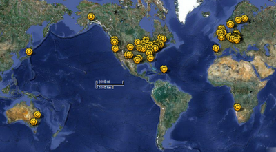
The title is self-explanatory, and this turned out to be quite a list! I'm still mystified at finding no solar system scale hikes in Russia, but I found 54 across Europe, Australia, Asia and Africa! Click on any of the individual links to find details about that walk... or click on any of thee pictures to see the interactive map of the world!

Scale Solar Systems all over the world
AUSTRALIA (Coonabarabran, New South Wales)
3-D planets accompanied by large billboards along the roads, creating the second largest scale model of the solar system. The Sun is represented by the 37 metre telescope dome at Siding Spring Observatory, and a single path leads through the inner planets to Jupiter. Tourists can choose one of five driving routes in various directions that lead to five different versions of all the outer planets.
Approximate Scale - 1 : 38 million (Total distance 410km or 254 miles roundtrip)

AUSTRALIA (St. Kilda, Melbourne, Victoria)
The "Melbourne Solar System" is to scale both in model sizes and distances. Starting with the Sun in the Triangular Reserve just north of St. Kilda Marina, the nine planets run along the bicycle paths to Sandridge beach Port Melbourne.
Approximate Scale - 1 : 1 billion (Total distance 11.8 km or 7.3 miles roundtrip)

AUSTRIA (Amstetten)
Nine planets along a beautiful nature trail on the western edge of the city, scaled in both distance and planet size. Begin with the Sun at Amstetten High School, and hike along the Mühlbach millstream "Black Path" to Pluto in Greinsfurth.
Approximate Scale - 1 : 1.5 billion (Total distance 8.4 km or 5.2 miles roundtrip)

AUSTRIA (Bernstein, Burgenland)
The Planet Trail begins at the Felsenmuseum Bernsteiner (rock museum) with a giant uniquely painted and strategically ripped iron sun, and up through Neptune in a circle around the village. Designed to come around within 250m of the starting point instead of a straight line, so you end up where you begin and don't have to backtrack. Planets are spheres atop serpentine boulders, connected by painted green and white markings.
Approximate Scale - 1 : 1.1 billion (Total distance 5.7 km or 3.5 miles roundtrip)

AUSTRIA (Freistadt)
Another long one! Driving or bicycling advised through the 11 stations of the Planet trail. Exact coordinates for all stops are at their GPS site. Start at the "walking stone" in Freistadt, up to Zimmerhofer farm, the mountain Church of St. Michael, the Mitterbach, through an animal refuge, and end at the private observatory of Professor Wolfgang Woess in the town of Sandl. Includes the Asteroid Belt, Pluto and a station with audible pulsar sounds.
Approximate Scale not noted (Total distance 31.6 km or 19.6 miles roundtrip)

AUSTRIA (Großraming)
A lovely nature walk partly through town and partly through National Park, beginning at the Großraming Municipal Office. Goes from Sun up to Neptune; Pluto is not included. Path continues on through Welser. Planets and distance both to scale.
Approximate Scale - 1 : 1 billion (Total distance 9km or 5.6 miles roundtrip)

Playground Solar System
AUSTRIA (Hellmonsödt)
Unique collection of planetary-themed playgrounds along a circular trial around the town. The Sun is a giant playland of monkey bars! Great for picnics, after which one can use the trail maps to visit the nine planets on the surround streets, coming back to the Sun from the opposite direction. Information boards also have info about Dwarf planets, Asteroid belt, Kuiper belt, comets, and the Oort cloud.
Approximate Scale - 1 : 1.5 billion (Total distance 6.5 km or 4 miles in circle)

AUSTRIA (Königsleiten)
Forest Königsleiten: Start at the metal relief sun on the wall of the Zeiss Planetarium Observatory, the highest in Europe! Planets and distance of the model solar system are to-scale; nine planets are marked by giant granite blocks, each showing information and reliefs. Trail proceeds through moors, meadows and bogs, with beautiful views of the peaks in National Park Hohe Tauern and the Salzach. Books also recommend the "Stargazer Restaurant" next to the planetarium!
Approximate Scale - 1 : 1.5 billion (Total distance 6km circular, ends again at Zeiss)

AUSTRIA (Lichtenberg)
Kinderplanetenweg, or "Kids Planet Trail" and also known as "Sunny Side Up!" begins at the municipal office of Lichtenberg. Follow the inner planets along the paths between old and Neulichtenberg, where 20 different species of trees were planted and labeled for nature hikes. The outer planets and their data stands are deeper in the woods on Anniversary Route, ending with Neptune.
Approximate Scale - 1 : 1 billion (Distance 7 km circular, ends again at start point)

AUSTRIA (Linz)
Linz, where Johannes Kepler lived and worked (1612-1626), holds one of the largest solar system models in Europe, extending over the entire province of Upper Austria. Known as the "Kepler Planterium", local organizations sponsored it as a "Land Art Project" where nine to-scale planetary sculptures were designed by renowned artists; including Pluto. Begins at the LAC observatory at the LAC along the Sonnenpromenade ("Sunwalk"), though website does not say if trails are a giant circle or linear paths. Maybe someday I'll get a guide at the LAC and check!
Approximate Scale 1 : 50 million (Distance not noted, but estimated around 300km)

AUSTRIA (Rettenegg)
University of Vienna Institute for Astronomy: The "Heaven on Earth" trail stretches from Rettenegg to Stuhleck in the foothills of the eastern Alps, to-scale in both planet sizes and distance. Start at the Star Pavilion, where the constellations of the northern summer sky are presented with 400 star points. Follow the trail along the nine planets, also Earth's moon, each placed inside glass orbs atop text panels. All planets are in the position of a particular day: May 5, 2000.
Approximate Scale - 1 : 1 billion (Total distance 12 km or 7.5 miles roundtrip)

AUSTRIA (Terfens)
Church of Vomperbach: "The Path of the Planets" goes through the the Forchat (pine forest) of the lower Inn Valley in the Karwendel nature reserve of the Tyrolean mountains. Starts with Sun outside Terfens at Vomperbach, and other planet stations are found inside Terfens and around Innbrücke, Wehle and Nepomuk.
Approximate Scale - 1 : 1 billion (Total distance 14 km or 8.7 miles roundtrip)

Solar System Walk in Japan
AUSTRIA (Tullnerfeld)
Vienna Woods: Begin at the Sun outside the church in Königstetten, and choose one of two paths, north or south, to Mars. On the north trail, a path tackles the outer planets up to Muckendorf's Inn Rödel along the Danube River. On the south, two different trails of varying difficulties follow outer planets, ending with one planet Pluto outside Hintersdorf, and one Pluto far south in Passauerhof. The many mapped trails to choose from can be hiked or bicycled.
Shorter two paths are each 10km or 6.3 miles roundtrip;
Larger path is 14km or 8.7 miles roundtrip though exact scales are not noted.

AUSTRIA (Vienna)
Begin at Wittgenstein's in southwest Vienna, and easily find the planet plaques along the grand wall of the gigantic Lainz Tiergarten near the star garden at George Berg. Planet pictures and distance all to scale. No map needed since the trail merely follows the wall, and find restaurants and the Wotrubakirche planetarium along the way. Inner planets closer to town, but finding Pluto requires going further into the woods near Gütenbachtor and the southern zoo, where the trail ends at Laaber gate. Earth's moon, Kuiper Belt and the Oort cloud are included.
Approximate Scale - 1 : 1 billion (Total distance 12 km or 7.5 miles roundtrip)

AUSTRIA (Weiten)
Südliches Waldviertel: Plan Tete trail in the forest district known as "Valley of Sun Watches" because in addition to the solar system model, there are collections of sun dials on display. Starts at the Sun opposite the old castle tavern, and follows the many planets past the sports arena, through cornfields and meadows; the Weitental lies between the two hills of the southern forest district, the Jauerling and the Ostrong. Includes Pluto and Earth's moon.
Approximate Scale - 1 : 16 billion (Total distance 7.2 km or 4.5 miles roundtrip)

BELGIUM (St. Vith)
Our Start at the Sun at the railway bridge in the Klosterstraße and end on the bridge in Galhausen, underneath the Mariengrot. Planets, including Pluto, represented by multi-colored orbs atop natural boulders.
Approximate Scale - 1 : 1.5 billion (Total distance 6 km or 3.7 miles roundtrip)

CANADA (La Malbaie, Québec)
Observatoire Astronomique de Charlevoix: Walk the path along the St. Laurent river for free or with an astronomy guide for $10 daily at 3pm to see the scale reproduction of the solar system called "Strolling at the Speed of Light". Starting at the Sun near the solar telescope at the Fairmont le Manoir Richelieu Casino, follow the planets and their info panels up through Neptune. Pluto not included.
Approximate Scale - 1 : 1.5 billion (Total distance 6 km or 3.7 miles roundtrip)

CROATIA (Zagreb)
Croatian National Theatre: Beginning with a huge metal Sun on Bogovićeva Street, travel through other various avenues and city squares to see to-scale metal planets on street corners, ending with Pluto under the Bologna underpass. Tough map! Not sure of distances in all one trip.
Approximate Scale - 1 : 680 million

Planet Walk in Czech Republic
CZECH REPUBLIC (Hradec)
Kralovehradecky Kraj: Distance and dimensional scale models of planets with information boards along a trail in Hradec Kralove near the Astronomical Society Observatory. Locations of all planets up to Pluto, plus Earth's moon and Halley's Comet are on the handy guide map – showing markers on streets, parks, ponds, businesses, schools and a dam.
Approximate Scale - 1 : 1 billion (Total distance 13 km or 8 miles roundtrip)

DENMARK (Durup)
Sallingsund and Environs Museum: "Planet Path Glyngøre" starts with a steel Sun in Glyngøre and goes out to Pluto in the Durup Square, with lovely views over Sallingsund along abandoned rail lines. Each planet is represented by a boulder monument, and a modern poster board has facts & figures, plus poetic verses about each planet in both English and Danish.
Approximate Scale - 1 : 1 billion (Total distance 12 km or 7.5 miles roundtrip)

DENMARK (Fjerritslev)
Fjerritslev Museum:The "planetenweg" in FjerritslevIn Fjerritslev, lies in the village of Han Herred in between the North Sea and the Limfjord, is a distance-scaled solar system replica containing all nine planets. Googled around in both English and Danish hoping to find details, but came up short on this one… anyone who has walked it? Please let me know any specifics!
Approximate Scale - 1 : 1 billion (Distance not found in any tour book resources)

DENMARK (Lemvig)
Lemvig Museum: "The Planetary Path" or planetstien at the edge of Lemvig town park follows the Limfjord sound past Vinkelhage, Søgårdevejen, and Gjeller Odde. Beginning with the giant bronze sun, go through the rest of the nine planets of granite & bronze plinths, where all planets are to scale, and distance is also to scale. Includes Earth's moon, Ceres, Halley's comet, and three positions of Pluto, accounting for it's variable oval orbit.
Approximate Scale - 1 : 1 billion (Total distance 10 km or 6.2 miles roundtrip)

ENGLAND (Otford, Kent)
High Street: Begin at the center Sun in the Recreation Grounds, whereby the planets fan out in a wide circle, as designated by the walking map. The position of the planet pillars depict the precise position of the planets in their orbits at midnight on January 1, 2000. Includes Earth's moon, and Jupiter's moons Io and Europa; also shows relative distances to Proxima Centuari in Los Angeles and Sirius in Sydney, Australia, among other stars.
Approximate Scale - 1 : 4.5 billion (Spreads over village, not intended as a trail)

ENGLAND (Somerset)
Maunsel Lock: Two for one! According to the tourist map for this double-walk, one can begin at the lock and choose two different paths through the solar system, north from the Sun to Pluto ending at Bridgwater, or south into Taunton. Each holds metal models set in stone monoliths, with descriptions of each planet.
Approximate Scale - 1 : 530 million (Distance 11 km or 6.8 miles in each direction)

Solar System Plaque
ENGLAND (York)
Bishopthorpe: A great bicycle trip! Start at the Sun near York College, follow the bike trails parallel to the A19 down to the town of Riccall. Planet descriptions and quizzes accompany the many raised, colorful orbs. Park facilities available for charity events and picnics.
Approximate Scale - 1 : 576 million (Total distance 20 km or 12.6 miles roundtrip)

FINLAND (Helsinki)
Ursa Astronomical Association: Scaled planets known as the "Ursa Model", best seen by bicycle or bus #14. Starts with the Sun atop a pillar at the Patterimäki hill in Pajamäki suburb, which rises over 50 metres above sea level and is thus visible by binoculars even to the most distant planet model, Neptune (Pluto not included).
Approximate Scale - 1 : 1 billion (Total distance 9 km or 5.6 miles roundtrip)

FRANCE (Rennes, Brittany)
Le Chemin Solaire or the Solar Path is outside Rennes in La Couyère, renamed "Starry Village" in 2011. Guides for the hike are available in the Community of Municipalities Mid-Vilaine and Semnon located in Bain de Bretagne, and has 3 color-coded levels of detail for the Sun and eight planets (Pluto not included): Orange for primary school children, green for teens and red for adults.
Approximate Scale - 1 : 2.2 billion (Spreads over village, not intended as a trail)

FRANCE (Strasbourg, Alsace)
International Space University: Planet walk extends along the northern bank of the Traun Traun bridge to the old power station Traun Marchtrenk. The starting point is a solar disk; the rest of the outdoor markers are planets in glass cases accompanied by data plaques.
Approximate Scale - 1 : 1 billion (Precise trail + distance not noted)

GERMANY
See existing list of 107 Planet Walks & Solar System Models in Deustchland here!

IRELAND, NORTHERN (Armagh)
Armagh Observatory & Planetarium of Northern Ireland: Trail known as the Astropark shows all the nine planets with orbs, and red and grey gravel stones to represent the Asteroid Belt. Grounds also include stone calendars and space for human orrery.
Approximate Scale - 1 : 30 billion (Total distance 8km or 5 miles roundtrip)

ITALY (Brunico)
The planet walk of Bruneck, in both Italian and German, starts near the Liberty Bar with a concrete sphere of the Sun. Across a bridge and around Sternwaldele to Bierkellerweg where one can get a view of Bruneck Castle, then around paths leading to Reischacher road and into forest land. Path of nine planets, each represented by boards, ends in the park by the Odeon Cinema. Very unique map!
Approximate Scale - 1 : 1.5 billion (Total distance 8km or 5 miles roundtrip)

Planet Walk in Austria
ITALY (Sudtirolo)
Santa Cristina, South Tyrol: the route of the former Val Gardena railway is now the promenade path of the "Sentiero Planetario" or Planetary Trail. Nine planets set to scale in size and distance with information boards holding various facts about each celestial body, including Pluto.
Approximate Scale - 1 : 1,868 billion

JAPAN (Tokyo)
Mitaka Campus: starting at the National Astronomical Observatory of Japan (NAOJ) building, follow the Sun to Saturn in the surrounding area, following informational boards. Pluto not included.
Approximate Scale 1 : 14 billion (Total distance can be seen with naked eye)

LIECHTENSTEIN (Vaduz)
Scaled plastic planets along a scaled hike along the Rhine River between Schaan and Bendern; start at the Sun at Rhine Park Stadium's parking lot and follow the Wuhrweg route toward Balzers.
Approximate Scale - 1 : 1 billion (Total distance 10km or 6.2 miles roundtrip)

NAMIBIA - Swakopmund, Erongo
Astro Farm Hakos: The "Heavenly Namibia" was designed as a sister-model to an identical planetenweg in Freiburg, Germany. Nine iron orb planets with steel décor sit atop wooden stakes, leading from the Hakos Guest Farm to the International Amateur Observatory (IAS).
Approximate Scale - 1 : 2.5 billion (Total distance 4 km or 2.5 miles roundtrip)

POLAND (Jakuszyce)
Orle: The "Model Ukladu Slonecznego" lies along a hiking trail in Gory Izerskie between the Orle and Chatka Gorzystow mountain huts. Distances are to scale, but plaques along the way are not to-scale in terms of planet size, but simply set into natural rocks. Pluto not included.
Approximate Scale - 1 : 1 billion (Total distance 9km or 5.6 miles roundtrip)

PORTUGAL (Estremoz)
Science Center of Estremoz: The Scaled solar system, or Sistema Solar à escala de Estremoz indeed covers the entire county of that name! Planets are represented with boards and are not to scale, but distances are calculated from the center of Estremoz, with Pluto out by the Évoramonte Castle. Starting at the Centro Ciência Viva de Estremoz at Convento das Maltezas, guides show where to find all markers, which include Pluto, and Ceres.
Approximate Scale - 1 : 4 billion (Circular, not intended as a trail)

PUERTO RICO (Arecibo)
Arecibo Observatory: Scale model of the solar system along trail that leads up to the observatory.
Scale and precise distance not known.

Solar System Drive in Sweden
SWEDEN
Stretches through most of Sweden… seriously! 
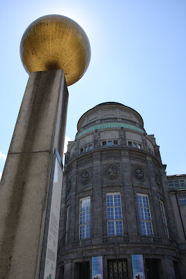
This scale model of the solar system is currently the largest in the world. It starts at the Ericsson Globe "Sun" in Stockholm, the largest hemispherical building in the world. Inner planets are all found in Stockholm, and the outer planets lie north in other cities along the Baltic Sea, including Danderyd, Märsta, Alsike, Uppsala, Gävle, Söderhamn, Umeå, and Luleå. Represented among the nine planets are many of their satellite moons, the Asteroid Belt, Halley's Comet and the Swift-Tuttle comet, plus Dwarf Planets Eris and Sedna. The model's northernmost point is the Termination Shock zone of the heliosphere, at the Swedish Institute of Space Physics in Kiruna. One can follow the Sun to Termination Shock in a straight line, though secondary road trips would be needed to see the comets in cities toward the South of the country.
Approximate Scale - 1 : 20 million (Total distance 1,234 km or 766 miles roundtrip)

SWEDEN (Örebro)
Örebro Astronomi cal Association: Begins with the Sun Monument at Olof Palme Square, and continues down Queen and Main Streets, which extend on a straight line through the business downtown area of central Örebro. Mercury, Venus and Mars marked with wall plaques. All other planets, including Earth and its moon, on stone pillars with steel planet models; continues on to Nikolai Church and the Iron Square, opposite the local castle, Örebro Slott. Ends with Neptune at the "Mushroom" water tower plateau, overlooking the city and the entire solar system path. Go to the local tourism office near the Sun Monument for guides and to-scale "Earth Pearls" to indicate size of our home planet as compared to the model.
Approximate Scale - 1 : 1.8 billion (Total distance 5 km or 3.1 miles roundtrip)

SWITZERLAND (Aarau)
Astronomical Association of Aarau: Starting with the Sun at the corner of Hauptstrasse at Echo Linde, follow the nine planets, plus Earth's moon, through the south trail of the forest; ends in town of Kölliken
Approximate Scale - 1 : 1 billion (Total distance 12 km or 7.5 miles roundtrip)

SWITZERLAND (Arosa)
Pratschli: Start at the bus Terminus at Pratschli, and follow beautiful labeled hike or guide map from Arosa Tourism office toward Pluto in Rot Tritt. The sun and nine planets are represented as models with information boards.
Approximate Scale - 1 : 2.8 billion (Total distance 4.4 km or 2.7 miles roundtrip)

SWITZERLAND (Bülach)
Kantonsschule Bülach: Start with the Sun at Canton School Unterland, east of the city center. Booklet map available from the school shows the path along the planets (includes Earth's moon) through town and to Pluto at the Bülacher Observatory.
Approximate Scale - 1 : 5 billion (1.5 hour hike)

SWITZERLAND (Burgdorf)
Astronomical Society of Burgdorf: Begin at the Binzbergplateau for a marvelous, all-green terrain nature walk through the solar system, north through Rüglen, a town called (no kidding) Egg, the Kaltacker schoolhouse, then the right fork toward Guetisberg, and from then on, all right forks through the forest to Rutschiweid and finally to Pluto in Wynigen.
Approximate Scale - 1 : 1 billion (Total distance 12 km or 7.5 miles roundtrip)

SWITZERLAND (Emmen, Lucerne)
Reusseggstrasse: Begin with the Sun at Reuss Schachen Emmenbrücke, at the edge of the Emme and Ruess Rivers, and follow the river directly east. Planet boards and models up to Pluto are along the trails up to the Pearl Bridge / Reussbrücke in Grunwald. Includes Earth's moon and Ceres.
Approximate Scale - 1 : 1 billion (Total distance 11.8 km or 7.3 miles roundtrip)

Giant Sun Model
SWITZERLAND (Falera Mirasteilas)
Astronomical Society of the Canton of Grisons: Start at the Sun along Er Liung just past via Cantunala, and follow the Falera Trail on the first part of the Panorama Route, which runs from about Falera Larnags to Laax-Murschetg. Includes all nine planets as individual sculptures, along stunning views of the Rhine Gorge. One trail leads on to Laax, another returns hikers to their starting point.
Approximate Scale - 1 : 4 billion (Total distance 3 km or 1.8 miles roundtrip)

SWITZERLAND (Kreuzlingen)
Kreuzlingen Observatory and Planetarium: Two planetary paths, each at a flat rate of CHF 100, go from the Sun at the observatory to Pluto along various trails, featuring signs showing planet orbs to scale. Hike north toward Germany to Bodensee-Therme (North Lake Constance thermal baths), or hike south to Siegershausen with trail maps to guide the way.
Approximate Scale - 1 : 1 billion (Total distance 12 km or 7.5 miles roundtrip)

SWITZERLAND (Laufen)
Nordwestschweiz: The Planetenweg Laufen is a hiking path from Laufen to Liesberg. Both size of planet models and distance are to scale, but the distances are linear and the trails are not. So, the walk is longer than some others with identical scales. Can be walked, bicyled or driven. Includes Pluto and Earth's moon.
Approximate Scale - 1 : 1 billion (Total distance 26km or 16 miles roundtrip)

SWITZERLAND (Locarno)
Astronomical Society of the Canton of Ticino: "Astrovia Locarno" begins with the Sun at the end Via al Lido on the River Maggia, and meanders along a green delta "quiet zone". Nine planets are represented with plexiglass, marble and steel models, accompanied by plaques with technical data. Cross the Morettinabridge to get to the outer planets, and through the Gerre Losone golf course. Also cross the footbridge on the bank of the River Melezza and onto the steeple in Tegna. Walk or bike through the green parks, and either hike back or take the Centovalli train to the starting point in Locarno.
Approximate Scale - 1 : 1 billion (Total distance 12 km or 7.5 miles roundtrip)

SWITZERLAND (Monte Generoso)
Vetta: Start with the 3-D Sun at the east forecourt of the hotel restaurants at Generosa Vetta observation deck (the very top), and follow the planet billboards along the eastern trail, across the border into Italy. Includes Pluto. Guide map available in Italian, German, French & English
Approximate Scale - 1 : 10 billion (Total distance 1.2 km or .75 miles roundtrip)

SWITZERLAND (Regensberg)
Lindenplatz: Starting with the 3.5 ton Sun (wow!) at the Linden Rain Village, follow varying trails (distances are about the same, but they have levels of difficulty for beginning vs. advanced hikers) through the nine planets. Concrete panels holding graffiti-proof prints on concrete slabs were created by local school children. Pass the town of Hochwacht and cross the Canton of Zürich border into the Canton of Aargu. End point is the Horn Castle, or Burghorn.
Approximate Scale - 1 : 1 billion (Total distance 12 km or 7.5 miles roundtrip)

Solar System Model in Denmark
SWITZERLAND (Ringgenberg)
Brienzersee (Lake Brienz ): Another dual setup, where one may choose two paths, both with stunning panoramic views! Begin with the large stone Sun at the Ringgenberg; the west trail of none planets through the Lake Thun Weissenau nature reserve ends with Pluto near Interlaken; the east trail along the massive lake, and then through small villages and forest lands, ends with another Pluto model near Oberried. Gorgeous visibility of surrounding mountains in all directions! Detailed MAP available at tourism office.
Approximate Scale - 1 : 1 billion (Total distance 12 km or 7.5 miles each)

SWITZERLAND (Saint-Luc)
Le Chemin des Planètes, or The Planet Path, begins at the FXB Observatory near Chandolin, and runs along a path in iew of the lovely Valais Alps. Model is to scale, but the walking distance is one scale and the scale of the nine planets is different: 1 cm to 1000 km.
Approximate Scale - 1 : 1 billion (Total distance 12 km or 7.5 miles roundtrip)

SWITZERLAND (Solothurn)
White Mountain: "Planetenweg Weissenstein" begins with a model of the Sun at the Kurhaus Weissenstein, the heads west to the mountain station of the chairlift Oberndorf, then further the white stone on the Hasenmatt to Grenchenberg. Markers re reminiscent of road signs, though more ornate and with stone carvings. Includes Pluto.
Approximate Scale - 1 : 1 billion (Total distance 12 km or 7.5 miles roundtrip)

SWITZERLAND (St. Gallen)
Botanical Gardens: Begin with the Sun at the Botanischer Garten, enjoy all the exotic plants and flowers while passing through the solar system scale model, which winds through Mörschwil to Glinzburg, and ends with Pluto in Obersteinach. Along the outer nature trails is a lovely view of Lake Constance.
Approximate Scale - 1 : 1 billion (Total distance 15 km or 9.3 miles roundtrip)

SWITZERLAND (Zürich)
Planetenweg Walking Trail from Uetliberg mountain station to the Adliswil-Felsenegg LAF cable car mountain station sports scale planet models and informational plaques set atop monoliths made from stones gathered on the Linth and Ruess glaciers. Local guides say to allow for a 2-hour hike, much of which is mountain terrain. Translation: uphill climbs!
Approximate Scale - 1 : 1 billion (Total distance 11.6 km or 7.2 miles roundtrip)

Solar System Scale Model in Europe